City councilors
have official roles that they play, especially where each serves as chair,
co-chair, or secretary on the committees to which they are assigned by the
council president.
In addition,
some councilors take on an additional role that they choose either consciously
or unconsciously based on individual personality, philosophy, or view of local
government.
Take for
example Council Vice President Piccirilli, who serves unofficially, either
consciously or unconsciously, as the Dampener
of Expectations. In both council and committee meetings, Councilor Piccirilli can
be counted on to answer impatient members of the public, who are insisting on immediate
resolution to their proposals, with these three momentum stoppers:
"These
things take time."
And…
"Government
moves slowly."
And…
"You know
what they say about making the sausage."
Often, I am
happy to hear him tap the brakes. It gives me hope that certain whacky pieces
of business before the council will die a slow death. But, does local government
always have to be slow? Aren’t there times when our legislative body can and
should press the pedal to the metal?
Watertown just
survived a highly unusual summer. While residents spent recent summers facing
drought conditions, this summer’s weather alternated between heat and humidity
and downpours. Beginning in late June, the ground became saturated, adding more
moisture to an overheated and disturbed atmosphere through constant
evaporation.
The
record-high average sea surface temperature of 76.8
degrees in the North Atlantic Ocean added to the potential for a series
of “perfect storms.” The more we learn, the clearer it becomes that Watertown dodged
a bullet or possibly multiple bullets.
Other
municipalities in our region were not so fortunate.
The
devastating storm that hit Vermont on Monday and Tuesday, July 10 and 11
turned out to be the canary in the coal
mine. Over those two days, parts of Vermont received two months
of rainfall. Montpelier, the capital, which is just a three-hour drive from Watertown,
got the worst of it. Montpelier's July
rainfall set an all-time monthly record of 12.06 inches, beating the previous
monthly record of 10.9 inches set in August 1989.
In many
parts of Vermont, prior to the July 10 storm, approximately eight inches of
rain had fallen since the last week of June — triple what’s considered normal
for that period.
Two people
died in the flooding and more than 4,000 homes and 800 businesses reported
damage.
Damage from
this storm has been compared to Tropical Storm Irene in 2011, which prompted Vermont’s
state government to spend heavily on shoring up its infrastructure. So this
wasn’t a case of total unpreparedness. It was bad luck that the July 2023 storm
exposed major infrastructure weaknesses that had not been addressed in the
aftermath of the 2011 storm.
Now, Montpelier
has a decision to make. They can decide to repair just the current damage,
which is extensive, and hope their bad luck is behind them, at least for
another decade. But that might not be a good gamble.
“It’s
definitely going to happen again,” said Lauren Oates of the Nature Conservancy
of Vermont. “It’s not a question of if, but when and how bad next time.”
Maybe Montpelier’s
leaders have already adopted a realistic sense of urgency and will opt for
something truly transformative. Something like an infrastructure Manhattan Project. Time
will tell.
Closer to
home, 40 miles to our south, Attleboro and North Attleboro were
hit with three consequential storms in three consecutive months.
On Sunday,
July 16, waves of
heavy rainfall thundered through the North Attleboro / Attleboro area, starting
in the morning and lasting into the night, causing flooding that overflowed storm
drains, and flooded streets, yards, and basements.
Almost exactly one month later on Friday,
August 18, the next storm hit, bringing heavy rain and strong winds.
Here’s one person’s vivid description:
"The
rain was just going sideways and the wind picked up more, which I couldn't
believe it …and the next thing I saw was sparks coming from the electrical line
and it was bouncing onto the street. It was the scariest thing I've ever been
through in my entire life."
The National
Weather Service later confirmed that the storm had spawned a tornado. One witness
said, ‘In the moments before it hit, it sounded like a train barreling
toward them.” Drivers on I-93 reported seeing cars hydroplaning.
The third
storm hit the Attleboro area a few weeks later on Monday, September 11,
and continued through the day on Tuesday.
Town officials
reported that there were around 200 homes with flood damage. Fire crews
responded to 145 calls for service, mostly for issues related to water and
flooding. They warned residents to avoid walking in standing water, which could
be contaminated with sewage.
And still,
the Attleboro area may have dodged a bullet.
As with the
previous storm, the National Weather Service confirmed the presence of a
tornado − actually a cluster of four tornados, striking Connecticut,
Rhode Island, and North Attleboro.
Might we be witnessing the development of a new “tornado alley,” spreading into Massachusetts?
The North
Attleboro tornado had estimated winds of 75 mph and a length of 370 feet, which
is about the length of a football field. Fortunately, it touched down in a
rural area, causing mostly tree damage.
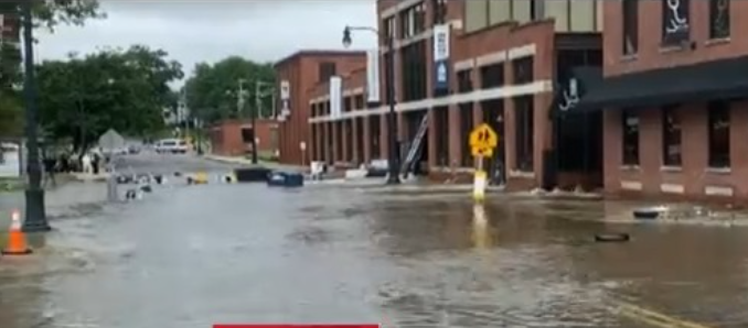
Here’s a
picture of a housing complex parking lot in Attleboro on Wednesday, September
13 after the storm had moved on. Notice the rushing water at the bottom of the
picture.

Meanwhile, 30
miles to our north, North Andover and Andover took three
consequential hits within a two-month period.
On Tuesday,
August 8, more than
six inches of rain fell within a six-hour period. Flood water reaching five
feet poured into homes and businesses. First floors and foundations naturally
received the brunt of the flood damage.
On
Friday, August 11, another
storm, producing three inches of rain, fell in a two-hour period, bringing
additional destruction to many of the same homes and businesses that were
damaged on August 8.
North
Andover, alone, sustained nearly $30 million in flood damage to public
buildings, schools, businesses, and private homes. Some roads were completely
washed away.
Here’s a picture taken in the North Andover business district.
As soon as
the cleanup began, Town Manager Melissa Murphy-Rodrigues reported that:
“Insurance claims have already started to be denied.”
On Friday,
September 8, a new
storm hit, targeting Andover. The high winds snapped tree limbs and ripped mature
trees out of the ground blocking streets, landing on homes, cars, and downing power
lines. There were widespread reports of live wires lying across roads and
sidewalks, leaving most residents and businesses without power.
Here’s a
shot that captures one section of downed trees and power lines.

And, lastly,
let’s look 36 miles to our west at the City of Leominster.
On Monday, September 11 a torrential storm, according to Mayor
Dean Mazzarella, “stalled out over the city as it delivered a
life-threatening amount of rain and flooding between 4 p.m. and 10 p.m..”
Roads were
left impassable, a heavily trafficked bridge collapsed, and hundreds of
residents needed to be rescued with boats.
The mayor
gave the early estimation for infrastructure repair costs at anywhere from $25
to $40 million. "That's just city infrastructure," Mazzarella said.
"We're trying to work on what assistance we can get to our businesses and
our homeowners. Homeowners are finding out that in many cases they're not
covered by insurance. And so we're trying to help them out."
The city
said a relief fund has been set up to support the residents affected by the
flood.
You have
probably seen pictures on local and national newscasts of the famous Leominster
sinkhole and the house across from it.

This
sinkhole resulting from road buckling is one of many. The home at the top of
the picture has now been officially condemned. If there’s a bright side to the
sinkholes, it’s that they are making it easier for DPW crews to replace ruptured
water and sewer pipes.
Stalled-out storms played a major role in the devastation brought to each of the four regions mentioned above. Instead of spreading the rainfall over larger areas of land, the stalled-out storms dumped record-breaking levels of rain and maintained longer periods of battering wind on those concentrated areas.
Those storms stalled out because
of blocking patterns, sometimes called atmospheric
traffic jams, that prevented those storms from continuing on their paths.
The overall
weather system moved slowly because of a blocking pattern in the
atmosphere that led to the storm’s low-pressure circulation getting stuck
behind a large area of high-pressure over Greenland.
So, now Watertown
has to worry about what is happening in the atmosphere over Greenland?
The answer
is: Yes.
To date, I
have watched approximately 50 TV interviews of residents who witnessed Mother
Nature’s destruction in those communities to our north, south, and west. There
is one outstanding common denominator. Longtime residents of 30 to 60 years in
those communities, were visibly stunned and made statements that boiled down to
this: I have never seen anything like this before.
So far, the weather
in 2023 has been much more extreme than most experts expected it to be, and it’s
anybody’s guess what this winter will have in store for us. Is there any reason
to believe that 2024, 2025, and beyond will be less extreme?
Does anyone
know what it would be like if two months of rain were to fall on Watertown in two
days, on top of saturated ground?
Would
low-lying roads, adjacent to the river, including Pleasant Street, Main Street,
and Watertown Street be flooded?
Would streets
buckle, causing sinkholes that would expose water and sewer pipes to further
damage?
How likely
is it that flood waters would be contaminated with sewage?
Would ground
saturation and high winds bring down trees and limbs on top of power lines,
killing power to the whole city?
Do we even
know enough to answer those questions?
Watertown
has a $10.5 million slush fund compliments of ARPA, the American Rescue Plan
Act. The city received 32 applications requesting a share of that fund. Some of
them would benefit a segment of the community. Some would benefit a sliver of
the community.
All of the
applications were submitted by the deadline date of March 26 – about 15 weeks
before the stalled-out storm flooded Montpelier and much of Vermont on July 10
and 11.
DPW has
applied for about half of the $10.5 million, specifying that the money would cover
the costs of replacing leaking pipes, and noting that 75 to 80 miles of
those pipes are over 100 years old.
Some
prominent voices, with their own pet projects, consider DPW’s request to be
greedy and unnecessary. In the environment in which we now find ourselves, I
think the amount of the request is woefully inadequate.
I have one final
question. Despite the alarming cluster of rarely seen weather events that have happened to communities
surrounding Watertown, do our leaders have an “it can’t happen here” mentality that
makes us all sitting ducks?
Quack.
Quack. Quack.
Bruce Coltin, The Battle for Watertown


No comments:
Post a Comment